


Hit the Trails at Hanging Rock State Park
Just 30 miles north of downtown Winston-Salem, Hanging Rock State Park offers one of the most rewarding outdoor escapes in the region.
Here, visitors can trade city streets for rugged cliffs, forested ridgelines, and some of the most scenic views in North Carolina’s Piedmont.
The park spans more than 9,000 acres in the Sauratown Mountains, a dramatic range often called the “mountains away from the mountains.” Explore the vast network of well-maintained trails that lead to cascading waterfalls, rocky overlooks, quiet forest paths, and panoramic summits that stretch for miles across the landscape.
With more than 48 miles of hiking trails, Hanging Rock offers options for nearly every type of explorer. Some routes are short and accessible, leading to iconic spots like Hanging Rock itself or the park’s beautiful waterfalls. Others climb steadily through hardwood forests to high ridges and lesser-known overlooks, rewarding hikers with quieter moments and sweeping views.
For visitors staying in Winston-Salem, the park makes an easy half-day or full-day adventure. Many travelers pair a morning hike with an afternoon back in the city exploring downtown shops, breweries, restaurants, and attractions, making Hanging Rock a natural extension of a Winston-Salem itinerary.
Below, we’ve organized the park’s trails by experience so you can quickly find the routes that best match your pace, interests, and sense of adventure.
Waterfall Hikes
There are 5 named waterfalls in Hanging Rock State Park. Here’s how to see them all. We’ve put them in a suggested order but you could just as easily explore these in reverse, ending at the visitor center to pick up your commemorative badge if you visit all five falls in one day.
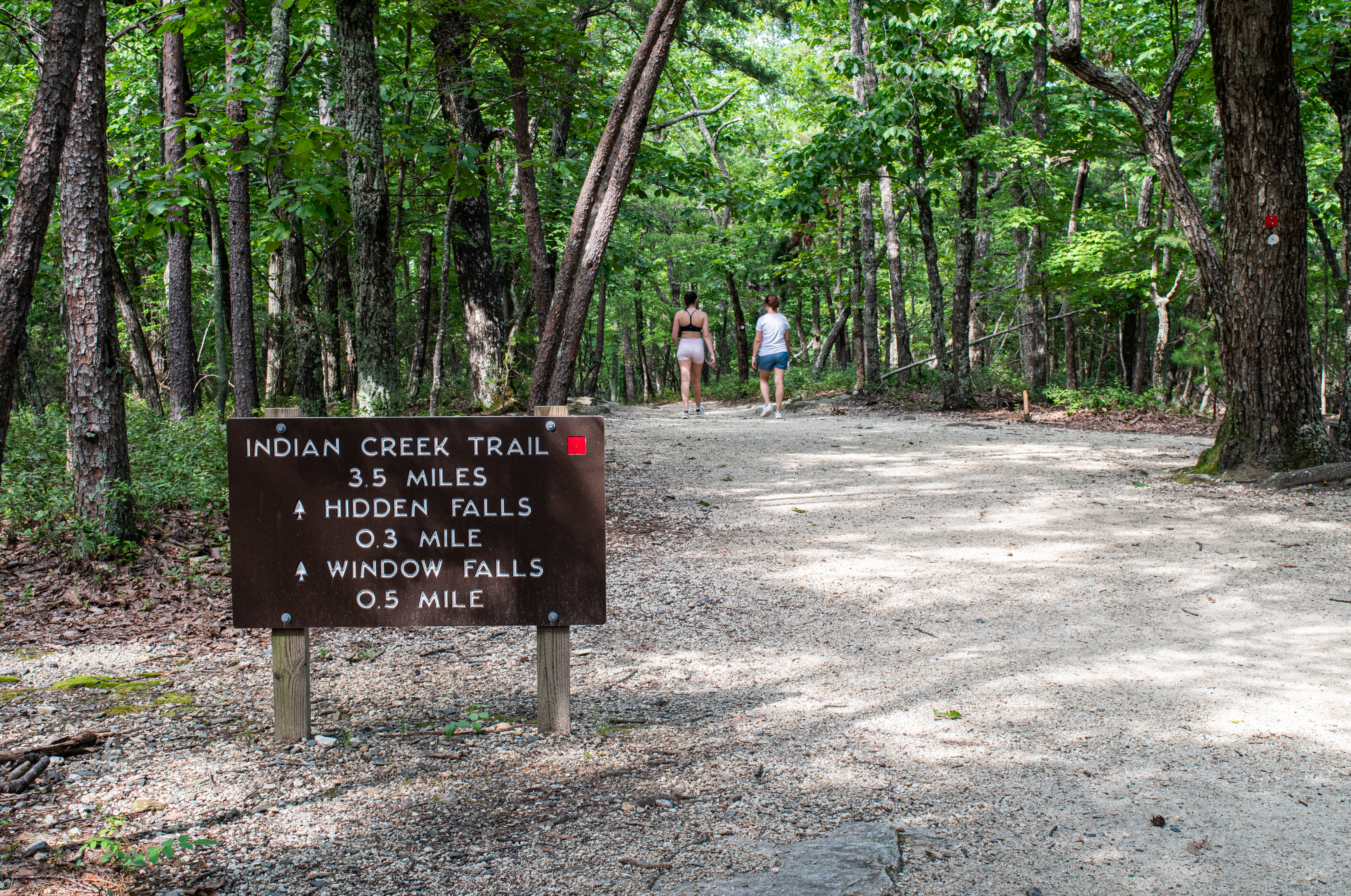
Hidden Falls and Window Falls via the Indian Creek Trail
Length: 1.2 miles round-trip
Trail type: out and back
Intensity/Rating: moderate
If you start your visit to Hanging Rock State Park at the visitor center, the trailhead is at the far right of the parking area, helping you to quickly see two waterfalls with a relatively short hike. The trail slopes down first to Hidden Falls – a smaller cascade best seen after a period of rain.
After exploring Hidden Falls, continue down the trail as it descends to Window Falls, which gets its name from the hole in the rock above the falls.
Upper Cascades Falls via Upper Cascades Trail
Length: 0.4 miles round-trip
Trail type: out and back
Intensity/Rating: moderate
While still parked at the visitor center parking lot, head to the opposite side of the parking area (to the left if facing the front of the visitor center) to access the Upper Cascades Trail. The trail follows a gentle slope down to the falls, eventually crossing a wooden bridge and viewing platform before descending a series of stairs to the base of the falls.
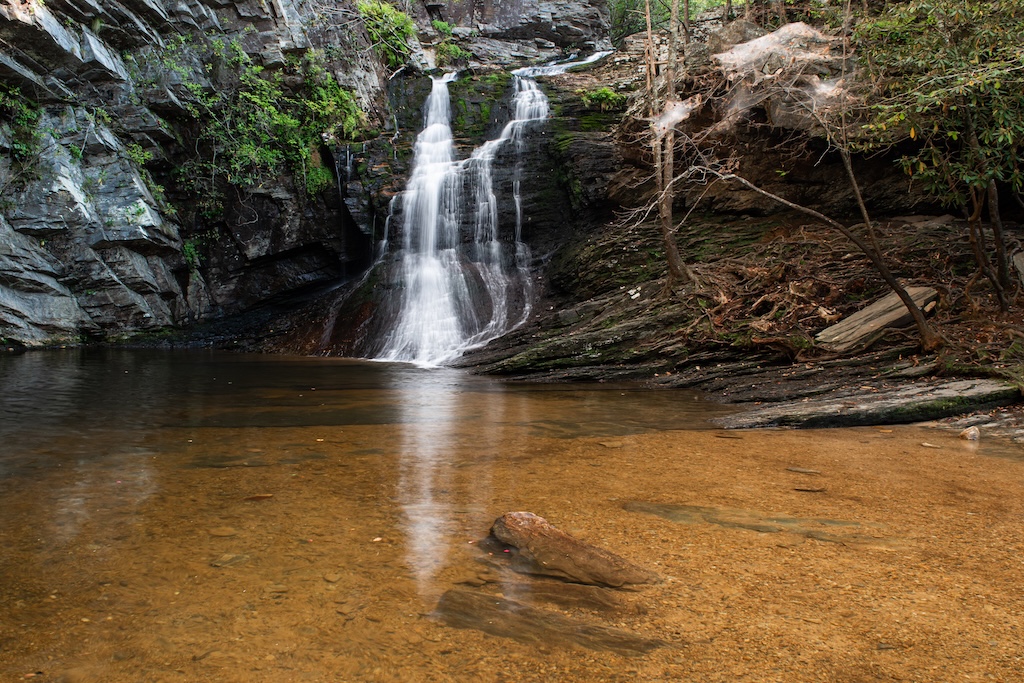
Lower Cascades via the Lower Cascades Trail
Length: 0.8 miles round-trip
Trail type: out and back
Intensity/Rating: moderate
After exploring the first three falls from the trails accessed at the visitor center lot, drive about 2.7 miles (5 minutes) to the Lower Cascades Parking Area (2143 Hall Road, Walnut Cove) to begin your hike to Lower Cascades. Hike through a beautiful forest setting before sloping down to reach the falls. The falls are in a cove with a dramatic rock wall. There is a large pool at the base of the falls, making it a popular swimming hole.
Tory’s Den Falls via Tory’s Den Cave and Waterfall Trail
Length: 0.4 miles round-trip
Trail type: out and back
Intensity/Rating: moderate
End your waterfall adventure before heading back to Winston-Salem by driving about 3.5 miles (7 minutes) to the Tory’s Den Parking Area. The parking area is located in a residential section. From the parking area, follow the trail and signage to the rock outcropping with a view of the waterfall. Tory’s Den Falls is a low flow waterfall and is best seen after a period of rain.
While this is the least dramatic of the five waterfalls, the rock outcropping also provides a stunning view. Please be sure to watch children and pets in this area as there are steep drop offs from the rocks.
Mountain Hikes

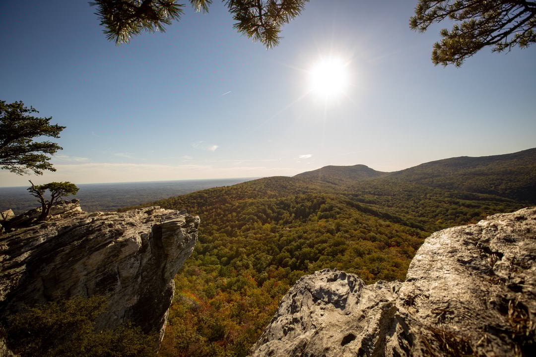
Hanging Rock via Hanging Rock Trail
Length: 3.8 miles round-trip
Trail type: out and back
Intensity/Rating: moderate to strenuous
Hike the namesake mountain of Hanging Rock State Park. This trail is well-traveled and well-signed. The trail begins with a gradual incline before some steeper sections. About halfway, the path levels a bit giving you a chance to catch your breath before the steep final 0.2-mile stretch to the summit. When you reach the top, take time to explore the panoramic views from the rock outcroppings on either side of the trail. Please watch children and pets in this area as there are steep drop offs from the rock outcroppings.
Moore’s Wall Loop Trail
Length: 4.7 miles round-trip
Trail type: loop
Intensity/Rating: strenuous
The trail leads to the Moore’s Observation Tower (Elev. 2,497) – a former fire tower and the highest point in the Sauratown Mountains. Enjoy beautiful views. For a slow elevation climb, hike the trail clockwise. Trailhead is next to the stone Bathhouse at the lake parking area.
Cook’s Wall Trail
Length: 4.4 miles round-trip
Trail type: out and back
Intensity/Rating: moderate
The sister peak to Moore’s Wall, this trail offers sweeping views, including a view of Pilot Mountain