


Peaks and Paths: Exploring Pilot Mountain State Park
Discover Scenic Routes, River Access, and Signature Views
Pilot Mountain State Park is a hiking paradise located a short 30-minute drive from downtown Winston-Salem. From trails that circle the mountain summit with 360-degree views to relatively flat trails through lowland pine forests at the base of the mountain to scenic walks along the Yadkin River, there’s plenty to choose from for people of all abilities and experience levels.
Here’s a look at the best trails at Pilot Mountain State Park by section of the park.
Mountain Trails
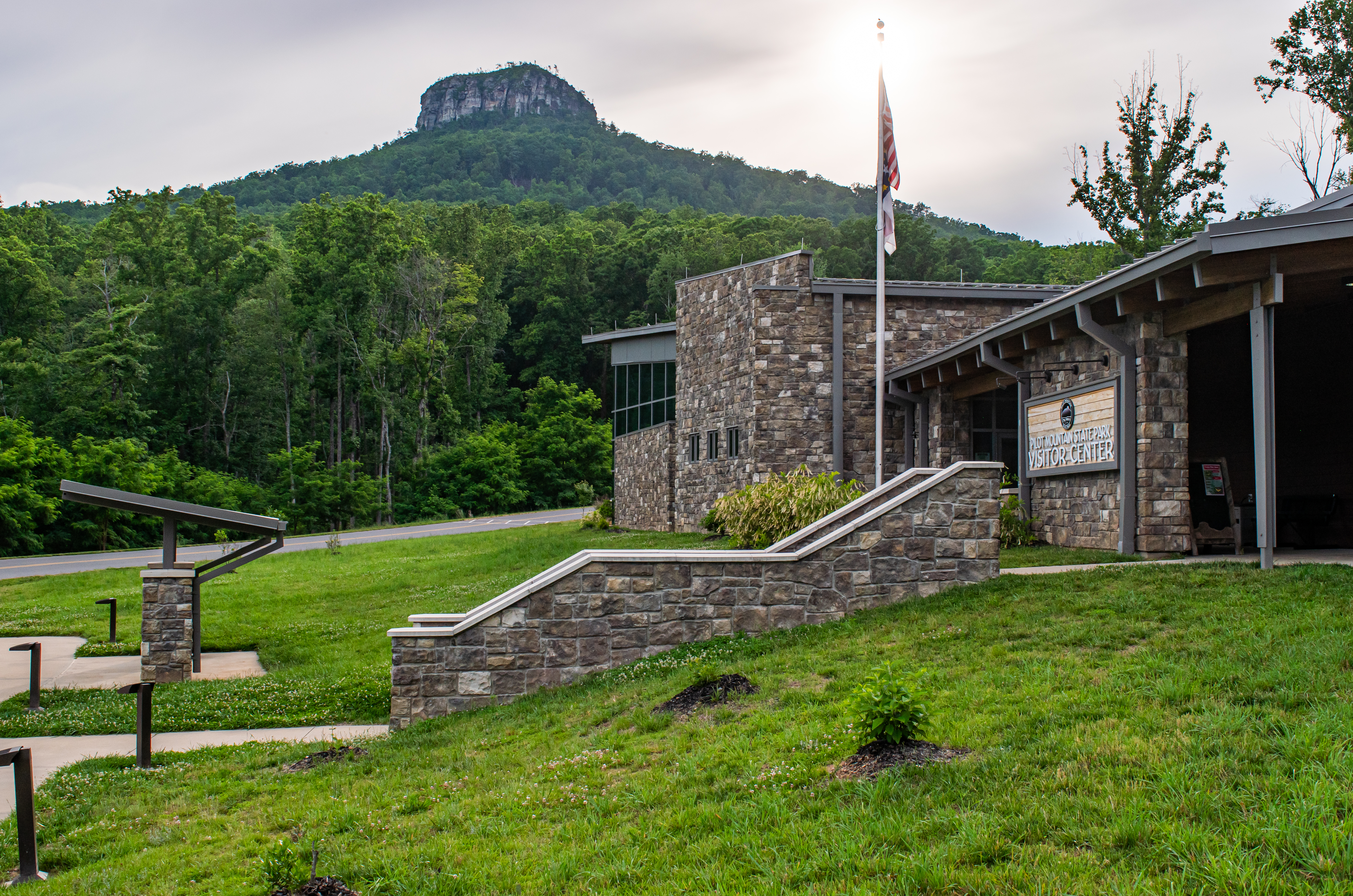
The Pilot Mountain State Park Visitor Center serves as your basecamp for a network of trails that help you explore the slopes and rolling hills around Pilot Mountain.
Grindstone Trail – A great way to experience Pilot Mountain up close and personal, this trail serves as an alternative to driving to the summit. The trail is considered strenuous due to the elevation gain and the 7-mile roundtrip distance. The Grindstone Trail connects to the Mountain Trail, which skirts the base of the mountain for 4.3 miles, and it connects to the Mountains-To-Sea Trail.
Fiddlehead Trail – Perfect for beginners or those looking to stretch their legs, the Fiddlehead Trail is an easy 0.4-mile trail from the visitor center that features a children’s Story Walk along the way. The Story Walk is a series of signs that tell a story. Connect to the Grassy Ridge Trail for a quick loop.
Grassy Ridge Trail – From the visitor center, walk through lowland pine and hardwood forests and cross meandering streams. This trail also serves as a connector to the Mountain Trail and the Corridor Trail.
Other Mountain Section Trails:
- Mountain Trail, 4.3 miles, one way, strenuous: Skirt the base of the mountain and follow the rolling hills. The primary access is from Pinnacle Hotel Road/Culler Road Parking Area
- Mountains-To-Sea Trail, 12.6 miles, one way, strenuous: This state-wide trail passes through the park beginning at the Corridor Trail and heads west before circling the mountain and exiting the park to the east.
Pilot Mountain Summit Trails

The summit of Pilot Mountain is capped by two pinnacles: Little Pinnacle and Big Pinnacle. All trailheads are easily accessible with a short walk from the summit parking area.
Little Pinnacle Overlook – This easy 0.1 mile trail (one way) that starts at the upper summit parking area takes you to perhaps the most iconic view in the park: a view of Big Pinnacle with long-range views of Hanging Rock State Park in the background. Along the way, you’ll see stunning views of the valley below.
Pilot Knob Trail – Just past the turn off for the Little Pinnacle Overlook is the turn for the Pilot Knob Trail. Descend a set of stone steps and you’ll begin a 0.8 mile roundtrip loop around the Big Pinnacle. As you walk around the Big Pinnacle, you’ll get an up-close look at the rocky cliffs and crevices. Look up to see hawks and ravens. And, get ready to see 360-degree views of the rolling landscape below.
Other Summit Trails:
- Sassafras Trail/TRACK, 0.3 mile round-trip, easy: Part of the Kids in Parks TRACKS Trail, this is a nice educational trail for family members to explore together.
- Ledge Springs Trail, 1.0 mile, one-way, strenuous: This challenging trail follows along the foot of cliffs and edges. It can be connected to the Grindstone Trail to create a loop.
Yadkin River Section Trails
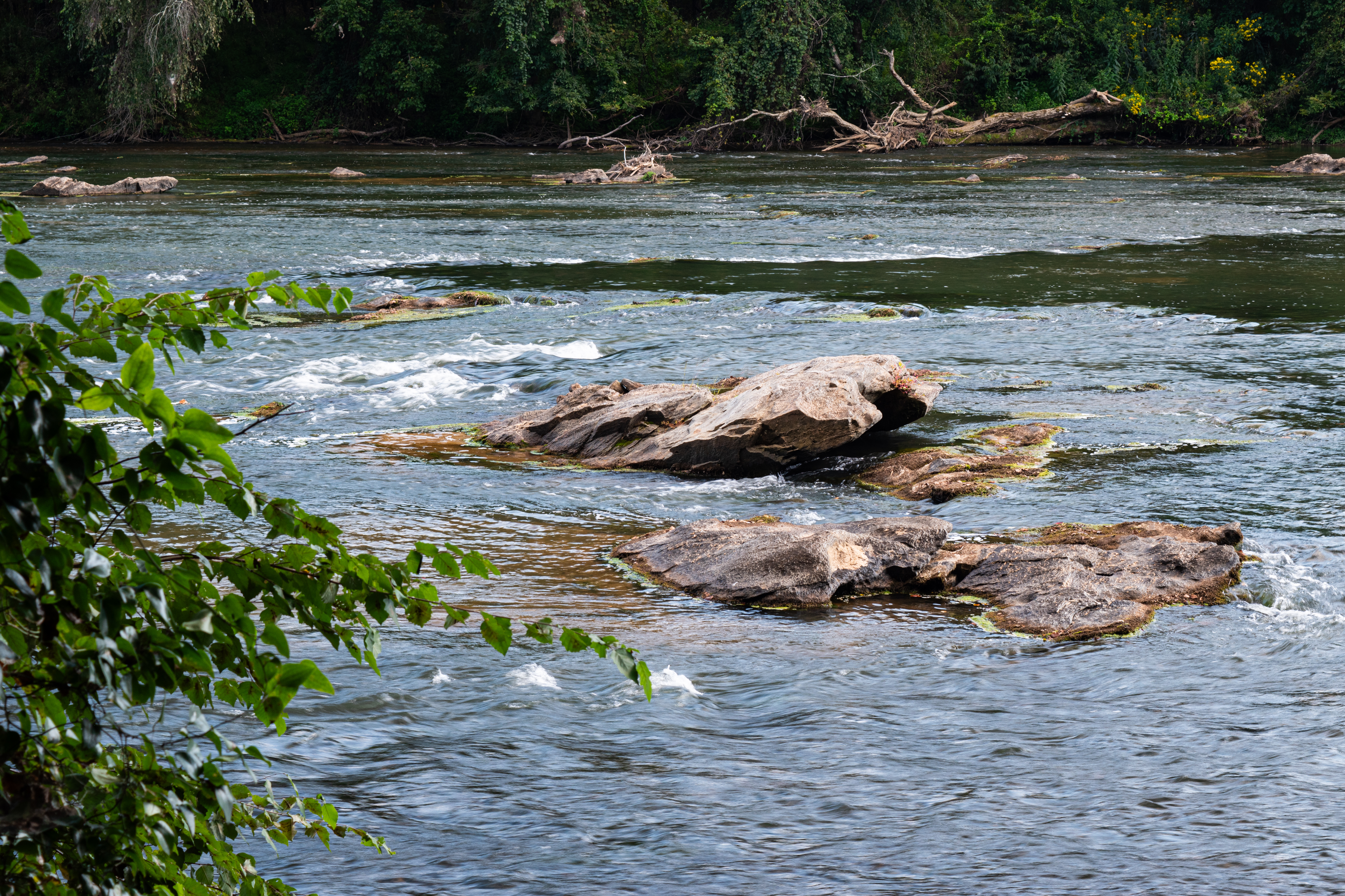
Take the trail less traveled and explore the more than 10 miles of trails along the scenic Yadkin River.
Bean Shoals Trail – Hike along the Yadkin River and explore the remnants of the Bean Shoals Canal, a project mysteriously abandoned in 1825 just five years after it began. This is an easy 1-mile roundtrip, out and back hike. The trailhead can be reached from the Bean Shoals Access. Drive to the parking area at the end of the road.
Horne Creek Trail – Enjoy the sounds of the Horne Creek and Yadkin River on this easy-to-moderate trail. The trail is 2.5 miles and eventually links to the Bean Shoals Canal Trail. From the Bean Shoals Access, drive the road until you see a small restroom facility and pull off on the left. This trail can be muddy after periods of rain.
Other Yadkin River Section Trails:
- Yadkin Islands Trail, 1.5 miles, one-way, moderate: This is a popular equestrian trail but is also utilized by hikers. Hikers can connect to the Bean Shoals Canal Trail. Access is from Bean Shoals.
- Ivy Bluff Trail, 1.3 miles, one-way, moderate: Ivy Bluff is the lone trail at the Ivy Bluff Access. You’ll begin on the bluffs before the trail slopes to the Yadkin River. You can make this trail a loop by circling through the small loop area at the end and heading back the way you came for a hike of about 2 miles total.
While you can drive directly to both sections of Pilot Mountain State Park, the 6.6-mile Corridor Trail has served as the connector between the Mountain Section and Yadkin River Section for hikers and equestrians since the 1970s.
The trail follows rolling hills and gains just 210 feet of elevation.
From the Mountain Section, park at the access point near the intersection of Pinnacle Hotel Road and Culler Road.
From the River Section, park at the lot at Hauser Road.