


Explore the iconic views and vast network of trails at Pilot Mountain State Park.
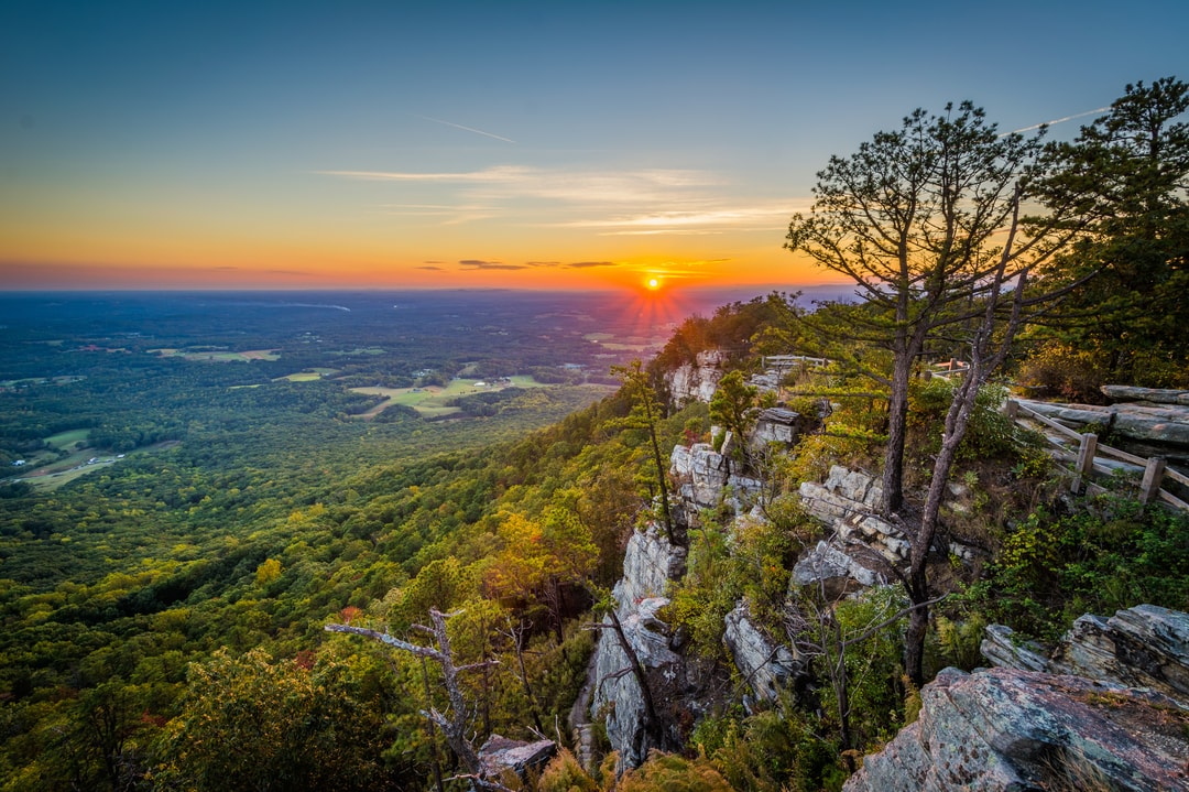
At the heart of Pilot Mountain State Park is an iconic natural landmark in the Sauratown Mountains that rises dramatically from the surrounding landscape. In fact, as you drive north on US-Highway 52 out of Winston-Salem toward Pilot Mountain, you’ll begin to see stunning views of the mountain from miles away.
Pilot Mountain State Park is split into two distinct sections: The Mountain Section and the Yadkin River Section. The two sections are connected by the 6.6-mile Corridor Trail. Or, you can drive and park at each section. Both sections are within a 30-minute drive of downtown Winston-Salem, making it an easy day trip from the city.
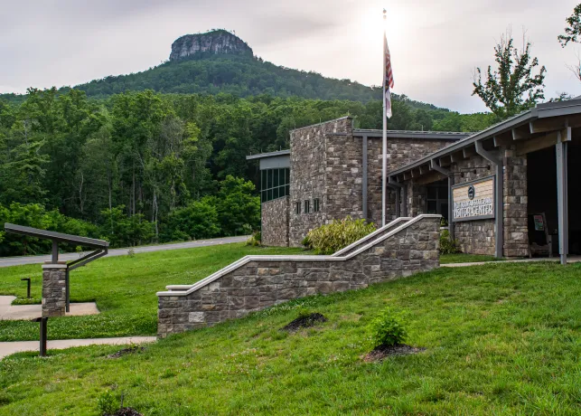
In the Mountain Section, exploring the namesake summit area is the defining experience in the park. Multiple trails and lookout points offer incredible 360-degree views, including (on a clear day) a view of the city of Winston-Salem. At the base of the mountain, a beautiful visitor center beckons you to learn more about the area’s geology and history, and it serves as the gateway to a network of trails.
In the Yadkin River Section, you’ll feel like you are a world away. Discover hidden gems as you explore the road less traveled in this rural area with a rich agricultural history.
The statewide Mountains-to-Sea Trail (MST) traverses both sections of the park.
History of Pilot Mountain State Park

Pilot Mountain is a quartzite monadnock, a term used to describe an isolated mountain. This mountain has survived for 500 million years while weather and other forces eroded the surrounding area into the rolling hills you see you today.
The mountain received its name from the Saura Indians who called it ‘Jomeokee’ – meaning the “Great Guide” or “Pilot.” The distinctive landmark lived up to that moniker and served as a guide for Native Americans and European settlers traveling the North to South route through the area.
Pilot Mountain was mapped in 1751 by a group that included President Thomas Jefferson’s father, Peter.
The Yadkin River section features the remnants of the Bean Shoals Canal. In 1820 The Yadkin Navigation Company was chartered to build the three-mile canal and lock system to help raise boats to canal level. The project was mysteriously abandoned in 1825.
In modern times, the mountain served as a commercial tourist attraction until 1968, when Pilot Mountain became North Carolina’s 14th state park. In 1970, 1,000 acres were added along the Yadkin River to create the Yadkin River section.
Pilot Mountain Trail Guide
From peaks to paths and everything in between, our guide to the trails at Pilot Mountain State Park will walk you through some of the top trails for hikers of all skill levels. Traverse your way to the summit or meander along the scenic and rural Yadkin River section before heading back to downtown Winston-Salem for the urban amenities. Keep reading to learn more!

Headline
Frequently Asked Questions
There is no fee to explore either section of Pilot Mountain State Park.
Hours for Pilot Mountain State Park vary by season. For the most up-to-date information, please visit www.ncparks.gov.
For the summit area of Pilot Mountain, the approach road is gated and hours are strictly enforced. At 15 minutes before close, park rangers circle the summit parking area and use a megaphone to advise guests to leave the park before the gates are locked.
Drive north out of Winston-Salem on US Highway 52 to access both sections of Pilot Mountain State Park. Both sections are within 30 minutes of downtown Winston-Salem.
For the Mountain Section visitor center and summit area, take Exit 27 (Pilot Mountain State Park) to Pilot Mountain Road. The Visitor Center is located at 1721 Pilot Knob Park Road, Pinnacle, NC. Other access points in the Mountain Section include: the Pilot Creek Access on Boyd Nelson Road and the Pinnacle Hotel Road/Culler Road parking area, which provides access to the Corridor Trail.
For the Yadkin River Section, the primary access point is the Bean Shoals Access. Take Exit 29 (Pinnacle) to Perch Road/Hauser Road and follow the signage for the Horne Creek Living Historical Farm. The park entrance is 0.4 mile past the farm on your left. The parking lot is 0.3 mile after the entrance. The other access point in the River Section is the Ivy Bluff Access on Shoals Road.
*Please note: Because the Yadkin River Section is in a rural area, you may have limited cell service. Plan ahead and prepare by having directions and a map available offline.
Yes, Pilot Mountain State Park features a visitor center in the Mountain Section at the base of Pilot Mountain. The visitor center is located at 1721 Pilot Knob Park Road, Pinnacle, NC.
The 6,500-square foot visitor center is relatively new, having opened in fall 2020, and features stunning panoramic views of Pilot Mountain. The modern facility is your central hub for visitor information, interactive exhibits and a gift shop for souvenirs. The visitor center has restrooms and a water bottle fill station.
There is no visitor center in the Yadkin River Section.
There are three ways to reach the summit of Pilot Mountain.
- You can drive to the summit of Pilot Mountain State Park. When entering the park, you’ll come to a traffic circle roundabout, stay to the right and follow the signs for the summit parking area. The road to the summit parking area is approximately 2.5 miles and is relatively steep with some tight turns. Allow 10-15 minutes to drive from the visitor center to the summit, especially during peak visitation times. At peak visitation times, the gate to the road to the summit may close if the parking lot reaches capacity. If the gate is closed, you’ll need to return later. On weekends and holidays, arrive early for your best chance to access the summit parking area. The gate is also locked outside of operating hours (which vary depending on the season).
- You can take a shuttle. During some weekends and holidays during warmer weather months, the park offers a shuttle service from the visitor center to the summit Parking Area. The summit shuttle is $5 roundtrip.
- You can hike to the summit via the Grindstone Trail, which travels 3.5 miles one way from the visitor center to the summit picnic area. The Grindstone Trail is a strenuous trail and is best for experienced hikers who are prepared for the 7-mile round trip hike. Hikers can also opt for a slightly shorter trail option and reach the pinnacle via the Pilot Knob Trail Loop, a 2.7 mile loop trail that is rated moderate and offers beautiful long-range views of the area.
The summit area of Pilot Mountain is the defining feature of the state park and offers you the opportunity to explore the two pinnacles that cap the mountain: Big Pinnacle and Little Pinnacle. From the summit parking area, you’ll have easy access to lookouts and trailheads (some of which are wheelchair accessible) and restrooms.
There is a picnic area just off the summit parking lot. See our trail guide to learn more about the trails at Pilot Mountain.
There are a wide variety of trails at Pilot Mountain State Park, offering options for hikers of all skill levels and abiliies. Some of the highlights include the Pilot Knob Trail, the Grindstone Trail, the Corridor Trail and the Bean Shoals Trail.
See our trail guide to learn more and pick the trails that are right for you.
Yes, the trails at Pilot Mountain State Park are pet-friendly. Pets must be on a leash at all times.
Please note that pets are not permitted to swim in the lake or to enter park buildings.
Most visitors to Pilot Mountain State Park enjoy exploring the summit area and visitor center, but the park offers numerous other activities.
- Hiking: Both the Mountain Section and Yadkin River Section offer more than 10 miles of hiking trails.
- Horseback Riding: Equestrian trails can be found in both sections of the park. There are several stables located just outside of the park that offer guided experiences.
- Rock Climbing: The rocky cliffs of the summit of Pilot Mountain offer ample opportunities for rock climbing and rappelling. Climbing is permitted only in designated areas. Climbing is not permitted on the Big Pinnacle, which is a sanctuary for nesting ravens and raptors and has been closed to all forms of climbing for more than five decades.
- Please note: All climbers must register before beginning a climb. Registration is located at the summit area.
- Paddling: Experience the scenic 2-mile portion of the Yadkin River that flows through Pilot Mountain State Park in a canoe or kayak. Paddling is the best way to explore two small islands, 45 and 15 acres in size, that lie in the river. You’ll also paddle past the historic Bean Shoals Canal wall that dates to the 1820s. The paddle launch is located at the Ivy Bluff Access on Shoals Road.
- Fishing: Cast a line from the banks of the Yadkin River and reel in smallmouth bass, spotted bass and catfish.
- Please note: You must possess a state fishing license and follow the regulations of the North Carolina Wildlife Resources Commission.
- Camping: In the Mountain Section, the lower slopes of the mountain house the tent and trailer camping area. There are 32 campsites. Each campsite has a tent pad, table and grill. Drinking water is available at the campground, and two bathhouses with hot showers are located nearby. There are no electrical hookups. Sites are open March 15 to November 30 and reservations are recommended. In the River Section, there are two primitive ‘paddle-in sites’ on the south side of the river 0.75 mile downstream from the Ivy Bluff Access paddle launch. Advance reservations are required.
- Please note: Camping is not allowed anywhere on the Yadkin River Islands.
- Picnicking: The primary picnic area is located near the summit parking lot. There are picnic tables and grills; drinking water and restrooms located nearby. The covered picnic shelter can accommodate up to 35 people and is available on a first-come, first-served basis.
No, the Horne Creek Living Historical Farm is a State Historic Site that is separate from the state park. It is adjacent to the Yadkin River Section of the park.
Horne Creek Farm dates back to the late 1800s and the historic Hauser Farmhouse has been restored and furnished to its circa early 1900s era. You can walk through the farmhouse and other buildings on site.
It is a working farm with livestock and other animals. The farm grows apples and sells a variety of products from its store/visitor center.
There is no fee to explore the farm.
Please note: Pets are not allowed on the grounds.
Show Us Your View!
Explore outdoors and share your view.
Whether you're blazing a new trail or finding a familiar path to wander, we'd love to see your view! Tag us in your social media posts with #VisitWS or #WinstonSalem for a chance to see your photos displayed here. Upload directly here.